

 RTI Act
Field Instrumentation (FI)
The Division has state-of-the art oceanographic and survey equipments required for acquisition of field data for implementation of different projects of the Division. Some of these are:
Acoustic Doppler Current Profiler (ADCP)
 An Acoustic Doppler Current Profiler (ADCP) measures current speed and direction by transmitting high-frequency bursts of sound though the water column. Particles in the water column scatter the sound back to the ADCP, which listens for these echoes, records them as data, and labels the different depths from which they have returned. Motion of the particles in the water column (such as movement with the current) causes the echoes to change in frequency. The ADCP measures this change, the Doppler shift, to determine current speed and direction at the different depths in the water column. The ADCP can measure current velocities through the water column either looking vertically downwards or vertically upwards. The measurement can be from a moving boat for synoptic current measurement of a large area or moored on the seabed.
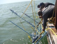
Valeport & Dobie Wave Gauge
 Valeport is also called as Directional Wave Recorder used for measuring waves and tides with a direction measuring mechanism called a flux gate compass and Valeport 2-axis EM current sensor. It has a range of 0 to 360° with accuracy ±1° and resolution 0.1°. It performs full onboard directional data analysis, allowing real time directional information at an unsurpassed 2° resolution. It is a cost-effective solution to directional wave monitoring requirements in all shallow water coastal applications. The current sensor works in the range ±5 m/s with accuracy of ±1% and a resolution 0.001m/s. This “PUV” type wave recorder use Linear Wave Theory to analyse the pressure and current oscillations generated by the wave action. The data processing is all carried out on board, giving you descriptive statistics, energy spectra, and high resolution directional spectra all in real time. All the raw data is logged as well, so it can be used in customised post-processing routines as well.
Dobie Wave Gauge is a self-recording system based on a pressure sensor to measure waves and water level changes. The Dobie is mounted inside a cylindrical steel housing welded to a steel gate that provided a stable platform resistant to sinking into the sea floor. When waves are passing overhead the Dobie deployed at the seabed, the fluctuating pressure, associated with the rising and falling of water, is recorded by the instrument. The fluctuations in pressure due to waves actually decrease in amplitude with depth below the mean water level (MWL), and the rate of decrease with depth depends on the wave period. Thus, pressure under long period waves can be readily felt, and measured at depth, but pressure fluctuations under short-period waves may not actually penetrate to the same depth.
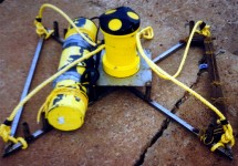
S4 Current Meter:
 S4 Current meter (spherical yellow colour) attached to stainless steel frame. The Dobie wave gauge is also seen attached to the same frame at one corner.
S4-Current meter – an electromagnetic current meter manufactured by InterOcean – is used to record near-bed water velocities. The S4 is designed to measure true magnitude and direction of horizontal current motion in any water environment. Water flows through the electromagnetic field created by the instrument, produces a voltage (potential gradient), which is proportional to the magnitude of the water velocity past the sensor. This voltage is then sensed by the two pairs of titanium electrodes located symmetrically on the equator of the sensor.
Shallow Seismic Profiler
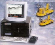 The Shallow Seismic Profiler or FM Sub Bottom Profiler manufactured by M/s. Edge Tech, USA is a versatile field instrument used for studying the stratigraphic structure and nature of the bottom sediments in the water bodies. It generates cross-sectional images of the seabed or lake and collects digital normal incidence reflection data over frequency range 2 to 16 kHz.
The sub-bottom profiler system consists of three components viz., the deck unit consisting of processor, amplifier, monitor, keyboard and track ball and the under water unit consisting of underwater cable and a towed vehicle. A 12-bit D/A converter generate the FM pulse. This FM signal is amplified approximately to100 V p-p by linear power amplifier in the deck unit. A piston transducer source converts the high voltage signal to an acoustic pulse. The acoustic returns from the sea floor are measured with the receiving array. The preamplifier mounted on the tow vehicle amplifies the output of the receiving array. A digital matched filter compresses the FM data into a sequence of high-resolution reflections. This passes into filters to display different bands of the processed spectrum. This instrument allows the user to select two overlapping frequency bands within the total bandwidth of the tow vehicle. The sonar display shows two sub-bottom images, one for each of the selected bands. The overlapping frequency bands enable the user to observe sediment structure of the bottom in different frequency bands. The system has the ability to strip away the water bodies and provide high-resolution sub-bottom images.
Piston Corer:
 The Piston corer is a long, heavy tube with a gravity weight attached on top, that is used to collect the sediment core from sea or lakes. The corer can be operated from the mechanised boat with a davit and winch facility. Corer can operated easily in areas of soft sea or lake bottoms where the penetration is higher resulting in the recovery of long cores. The sediment cores are useful in studying the Quarternary paleoclimate, sedimentology and volcanic history.
Echo sounder:
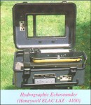 Echo sounder is used for depth measurement, and preparing the bathymetric map and data input for numerical modeling. The echo sounder used in the study is a portable shallow water echo sounder capable of measuring up to a depth of 60m. It operates with a combined 35/200 kHz transducer as transmitting and receiving transducer. The transducer can be mounted at the boat’s bottom or as portable version attached on the side of the boat/vessel. It can be operated at four depth ranges :0-18m, 15-33m, 30-48m and 45-63m with an accuracy of 0.25% of selected scale range. The echo sounder uses analogue recording paper for recording the bottom echo. The analogue data can be read for the precise depths at different positions.
Differential Global Positioning System:
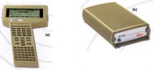 GPS is a navigational aid, which is used to locate the position and altitude based on satellite positioning. The equipment used for position fixing initially was the Magellan GPS NAV 5000, which is manufactured by Magellan Systems Corporation, California. The NAV 5000 is generally capable of better than 100 meters horizontal accuracy in autonomous operation. It uses five channels working simultaneously to locate and collect data from the GPS satellites. The data received from the satellites is rapidly processed to compute current position, altitude, velocity and navigational data in less than one minute. Though it can compute the altitude it is not a reliable estimate. A Real Time Kinematic GPS- SR9400 with accuracy of the order of 1m was procured subsequently under the project. This is manufactured by Leica, Switzerland. It consists of two sets of receiver and controller, one as a base unit and the other as a rover unit. The real time surveying is made possible by using a radio modem, which links between the base and the rover.
Sediment Traps:
 The sediment trap is a field instrument when deployed in the sea, provides the quantum of suspended sediment load in the seawater over a period of time. It is made of PVC pipe with a diameter of 9 cm and length 35 cm. The bottom end is closed using an end cap. Two types of sediment traps could be used. Those placed in the bottom layers or in zones of high sedimentation have a nozzle or a reducer in the top to provide a reduced opening of 4 cm. This is to take care of the anticipated higher sediment load in the bottom layers that might result in overfilling. Further from the seabed where the suspended load is less, there is no need for a nozzle. The trap, which is kept very close to the bottom, is made in such a way that it can be kept in a horizontal position with an opening on its side using a connector. The sediment traps mounted on the sensor housing are open when deployed in the sea. Before retrieval the traps are closed by sending a diver to the depth of deployment.