

 RTI Act
Hydrology Group (HyG)
Critical Zone Observatories
NCESS is setting up Critical Zone Observatories (CZOs) in South Peninsular India under the theme TERRAIN (Tropical Ecosystem Research Observatories in Peninsular India with an objective to understand the relative influence of natural perturbations (climate variability) and anthropogenic activities on the hydrological and biogeochemical cycles in different agroclimatic regions of India which will be elevated to the standards of global test bed for Critical Zone studies. In the first phase, CZOs has been set up in the Attappadi (Sub-Humid to Semi-Arid transition zone), Munnar (Humid - High altitude mountainous terrain) and Aduthurai (Tropical wet and dry deltaic region) representing different agroclimatic zones. These CZOs are being instrumented to monitor instantaneous and continuous soil moisture (surface and profile), groundwater level, streamflow, canopy characteristics (Leaf Area Index, Vegetation Water Content, Biomass), porewater geochemistry, hydrochemistry of surface and groundwater, soil properties (physical and hydraulic properties), meteorological variables, evaporation, soil water balance (Lysimeter) etc. These variables are monitored at different spatio-temporal scales and the data generated from these observatories will enable to understand the Critical Zone dynamics and its resilience in the context of natural and forced changes.
Attappadi Critical Zone Observatory
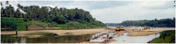
The Attappadi CZO lies in the transition zone between the humid areas of Silent Valley National Park to sub-humid areas in the Nilgiri Plateau and extends to semi-arid region. The CZO is situated between E longitudes 76°25’to 76°50’and N latitudes 11°0” to 11°30’ and covers an area of 1225km2. Monitoring stations has been setup in the Palur watershed (8.5 km2 area). The river Bhavani, which is the tributary of east flowing Cauvery river, originates from the Nilgiri mountain ranges of southern Western Ghats. The river drains nearly 8% of the total area of the Cauvery Basin. The important tributaries of the Bhavani are the Siruvani, the Kundah, the Conoor and the Moyar. The river has a catchment area of 6,200 km2 which is spread essentially over Tamil Nadu (87%) and partly in Kerala (9%) and Karnataka (4%) states. The Bhavani basin is characterized by a considerable amount of tribal population and is predominantly an agricultural watershed. Characterization of soil physical, chemical and hydraulic properties is ongoing in the Attappadi CZO. Surface and groundwater hydrochemical characterization of the Attappadi CZO is progressing through continuous sampling.
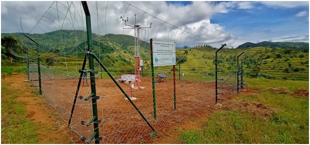
Munnar Critical Zone Observatory
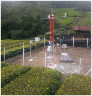
Munnar CZO is a tropical high altitude mountainous observatory, characterized by a highly heterogeneous terrain. The CZO encompasses the watersheds of Mutirapuzha, Idamalayar and Amaravati rivers. Monitoring stations has been setup in Matupetty and Vattavada regions of the Munnar CZO. Geologically the area forms a part of the Madurai granulite block (MGB) of the southern granulite terrain (SGT) and comprised essentially of charnockites, hornblende gneiss, granite etc. Geomorphologically the area forms a part of Munnar plateau whose elevation varies between 1460 and 1620 m above msl. The slope is generally steep (>30°) and the soil is mainly of lateritic type with appreciably high content of clay and organic matter. The hills of Munnar are home to different cash crops. Tea gardens and settlement with mixed cultivation are the major land use of this area. Eucalyptus and acacia, planted under the government’s social forestry scheme, occupy a major part of the forest plantation, whereas the upslope portions are occupied by degraded forests and shola grasslands. On the other hand, the Amaravati watershed are generally occupied by cold climate driven vegetation. The contrasting climatic conditions and agricultural activities makes the CZO unique in many aspects.
Aduthurai Critical Zone Observatory
Aduthurai CZO is located in the Cauvery delta in the eastern part of Tamil Nadu and experiences a tropical wet and dry climate. This CZO is predominantly an agricultural watershed with rice as the principal crop. The region experiences an average annual rainfall, of about 1000 mm with North East monsoon being the major contributor (550 mm) of the annual rainfall. The Cauvery delta region is generally known as the Rice Bowl of Tamil Nadu and is also the largest coconut producer in Tamil Nadu. The upper part of the Cauvery Delta is bordered by Cuddalore lateritic sandstones of pilo-miocene age and majority of the delta is covered by alluvium. The south eastern part of the delta constitutes the coastal lands. Aduthurai CZO will be augmented with monitoring stations shortly.
Critical Zone Laboratory at NCESS
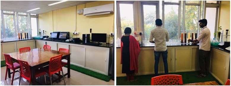
Critical Zone Laboratory has been setup at NCESS for carrying out laboratory scale experiments on soil, water and vegetation. The laboratory is equipped with
- Soil Hydraulic Property Estimation setup – HYPROP, KSAT
- Dual Head Infiltrometer, Mini Disk Infiltrometer
- Automatic Soil Particle Size Analyzer – PARIO
- Hydrometer, Sieve Shaker, Pore Water Sampler
- Plant Canopy Analyzer, NDVI Meter
