

 RTI Act
- You are here:
-
Home

-
Publications
- Research Updates
Research Updates
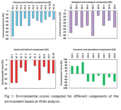 The increase in demand of building stones and construction-grade sand has resulted in aggressive hard rock quarrying in many parts of the world. The problems are to be evaluated in detail for the judicious use of resources on the one hand and ensuring health of the ecosystems on the other. The present study aims to evaluate the impact of hard rock quarrying on one of the important twin - river basins in SW India, the Netravati–Gurpur river basin, which hosts the fast developing urban centre, the Mangalore city. A total of 64 hard rock quarries are located in the basin which together extracts about 6.75 million t y−1 of rocks/rock products for different purposes. An assessment of the impacts of quarrying using the rapid impact assessment matrix (RIAM) reveals marginal, short-term positive impacts in economic-operational components but major negative impacts on all the other environmental components. The study indicates that the present intensity of quarrying is unsustainable with a sustainability index of − 0.25. Therefore, hard rock quarrying in the study area is to be strictly regulated for bringing down the river basin degradation to the barest minimum level and maximizing the ecosystem benefits to its full potential.
Bibliographic Info: Vandana, M., Shiekha E. John, Maya, K., Syam Sunny, Padmalal, D. [2020]. Environmental impact assessment (EIA) of hard rock quarrying in a tropical river basin - study from the SW India. Environmental Monitoring and Assessment, Vol. 192 (9), Art. 580. https://doi.org/10.1007/s10661-020-08485-x
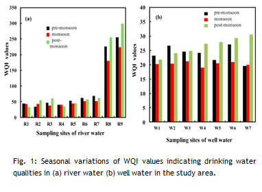 The current river basin monitoring study investigates the standards of the quality of the river and well water in a biodiversity-rich Netravati River basin in Karnataka state, India. Water samples were collected from 16 major sampling sites during pre-monsoon (April), monsoon (August) and post-monsoon (October) seasons in 2017 to ascertain its physico-chemical parameters. The results of the tests were compared with maximum permissible limits proposed by the World Health Organisation drinking water guidelines. The Water Quality Index (WQI) and the Irrigation Water Quality Index (IWQI) using parameters such as Sodium Percentage (Na %), Magnesium Hazard (MH), Permeability Index (PI), Sodium Absorption Ratio (SAR) and Residual Sodium Carbonate (RSC) have been determined to provide a better understanding of its drinking and irrigation water quality. The interpreted WQI values of the water in Netravati River vary from 33.21 to 298.66, which fall in the range of excellent to very poor drinking water quality. In the case of well water, 100% falls under the excellent category. Multiple statistical methods like Principal Component Analysis (PCA) and Pearson correlation analysis were used, and the results of PCA were found to be in a correlation with the results of the Pearson correlation analysis method. The study, as a whole, highlights the importance of the application of PCA, WQI and IWQI as standard methods to evaluate the quality of water. The results of the present study could be used to contemplate regulations to improve the water quality standard and help people living in and around the river basin to understand the current status of the water quality they use for various purposes.
Bibliographic Info: Sandhya Sudhakaran, Harsha Mahadevan, Arun, V., Krishnakumar, A., Anoop Krishnan, K. [2020]. A multivariate statistical approach in assessing the quality of potable and irrigation water environs of the Netravati river basin (India). Groundwater for Sustainable Development, Vol. 11, Art. 100462. https://doi.org/10.1016/j.gsd.2020.100462
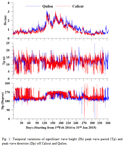 The Southwestern Shelf Sea (SWSS) of India has a distinct wave pattern, which makes it different as compared to the adjoining regions. Wave directional spectra during the monsoon season are comparatively broader and double peaked in contrast to that of the western shelf sea. The well-defined directional bi-modality is observed during the south west monsoon which is attributed to the coexistence of the south Indian Ocean swells and the southwest monsoon swells. The shamal swells generated by the shamal wind blowing from the Arabian Peninsula are found to have a significant influence on the wave pattern of the SWSS. In addition, the local sea breeze/land breeze also contributes significantly to the observed changes, particularly to the diurnal variation. A distinct phase lag in occurrence of the maximum significant wave height for the wind sea component is also observed in the northern region of the SWSS during the fair seasons.
Bibliographic Info: Anoop, T. R., Sheela Nair, L., Prasad, R., Reji Srinivas, Ramachandran, K. K., Prakash, T. N., Balakrishnan Nair, T.M. [2020]. Locally and remotely generated wind waves in the southwestern shelf sea of India. Journal of Coastal Research, Special Issue 89, pp. 77-83. https://doi.org/10.2112/SI89-014.1
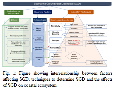 Submarine groundwater discharge (SGD) is an important process driven by marine and terrestrial forces. Low tide affects SGD the most, therefore the ideal time to detect SGD is the low tide, especially during spring tide. Techniques to detect and quantify SGD along with the understanding of the related aquifer characteristics is discussed in this study. Scientific community across the world is realizing the importance of studying and mapping SGD because in the scenario of climate change, this part of the global hydrological cycle is an important process and is known to have a significant effect on the marine ecosystem due to nutrient and metal inputs around the region of discharge. Therefore, understanding the processes governing SGD becomes very important. In this review, various components and processes related to SGD (e.g., Submarine Groundwater Recharge, Deep Porewater Upwelling, Recirculated Saline Groundwater Discharge), along with detailed discussion on impacts of SGD for marine ecosystem is presented. Also, it highlights the future research direction and emphasis is put on more research to be done keeping in mind the changing climate and its impacts on SGD.
Bibliographic Info: Suresh Babu, D. S., Ashwini Khandekar, Chandrashekhar Bhagat, Ashwin Singh, Vikrant Jain, Mithila Verma, Brijesh K. Bansal, Manish Kumar [2020]. Evaluation, effect and utilization of submarine groundwater discharge for coastal population and ecosystem: A special emphasis on Indian coastline. Journal of Environmental Management, Vol. 277, Art. 111362. https://doi.org/10.1016/j.jenvman.2020.111362
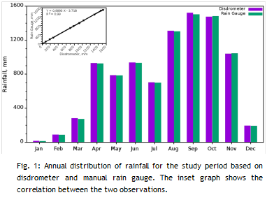 In the present study, seven-year-long observations of rain microphysical properties are presented using a ground-based disdrometer located at Braemore; a site on the windward slope of the Western Ghats (WG) over the Indian Peninsula. The annual cycle of rainfall shows a bimodal distribution with a primary peak during summer monsoon and secondary peak during pre-monsoon. Pre-monsoon rain events are less in number but are with high intensity and characterize large raindrops and low number concentration. During summer monsoon, short and less intense rain events with small drops are noticed. Post-monsoon rain is having a long duration less intense events with lower concentration of large raindrops compared to the summer monsoon. In the seasonal variation of mean diameter (Dm) and raindrop concentration (NT ) with Rain Intensity (RI), winter and pre-monsoon rains exhibit higher values of Dm and lower values of NT compared to the summer and post-monsoon seasons for all the RI ranges. The mean features of the rain microphysical parameters are also supported by the case studies of rain events. RI, Dmand N T are categorized into different range bins for all the seasons to identify their variation and relative rainfall contribution to the total seasonal rainfall. Heavy drizzle/Light rain has maximum rain duration, and the relative contribution to the rainfall is high from heavy rain type. Winter and pre-monsoon rains are mostly contributed from the larger raindrops (>Dm 3), and during summer and post-monsoons it is from Dm 2 onwards. The distribution of occurrence frequency of NT and rainfall are similar during all four seasons. NT 2 recorded rainfall percentage nearly the same as NT 1 in summer monsoon and this also supports large number of raindrops in this season. In RI-Duration analysis, all seasons showed similar distribution, and 90% of total duration is contributed from RI with less than 20 mm h-1.
Bibliographic Info: Sreekanth, T. S., Hamza Varikoden, Mohan Kumar, G., Resmi, E. A. [2019]. Microphysical features of rain and rain events during different seasons over a tropical mountain location using an Optical Disdrometer. Scientific Reports, Vol. 9 (1), Art. 19083. https://doi.org/10.1038/s41598-019-55583-z
News and Events
Research Updates
- Metamorphic and tectonic evolution of the Southern Granulite Terrane, India
- Origin of TTGs and high-K granitoids in the Bundelkhand Craton, Central India
- Detrital zircons in crustal evolution: A perspective from the Indian subcontinent
- Age of Kaladgi Supergroup, India
- Geochemical provenance of an Indo- Arabian stone anchor from Manikapatna
- Paleo fluids in the petroliferous basins of western offshore, India
- Need for long-term plans to restore the water quality of the rivers of Southern Western Ghats
